How a City Used Advanced Tech for Mitigating Road Safety Risks
Can technology help reduce accidents and fatalities at busy intersections? The city of Bellevue in the state of Washington, turned to LiDAR and Outsight to help answer this question.
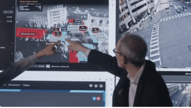
Without the use of cameras or facial identification, LiDAR helped the city's administration detect and classify various road users (pedestrians or vehicles) at all times of the day.
Photo: Outsight
3 min to read
According to data collected by the city of Bellevue, Washington, 55% of all fatal and serious crashes involved a pedestrian or a cyclist. In a further indictment of urban planning, 41% of all pedestrian fatalities and serious injuries occured due to the failure of vehicles to yield to pedestrians.
As part of its Vision Zero Initiative, the city of Bellevue aimed to eliminate traffic deaths and serious injury collisions on city streets by 2030. This includes considering the design, infrastructure and systemic issues behind crashes, as well as carrying out periodic progress assessments across all domains of the initiative.
Ad Loading...
Foreseeing the need for actionable data to achieve this objective, the city is adopting a range of physical and digital solutions, including the use of software from Outsight to develop a long-lasting framework for road safety.
Raul Bravo, President and founder of Outsight stated that "with the rise in new forms of mobility, it is essential that our infrastructure evolves to ensure the security of all without compromising on efficiency, and the Vision Zero Initiative provides a beautiful way to strive towards the same.”
Data collected was processed and streamlined into actionable insights, making sure that the city stayed adequately informed throughout their entire decision making process.
Photo: Outsight
Collecting Accurate and Actionable Data With LiDAR
In seeking to achieve these objective by 2030, Bellevue turned to LiDAR to provide usable data regarding road usage trends, while retaining user privacy.
Without the use of cameras or facial identification, LiDAR helped the administration detect and classify various road users (pedestrians or vehicles) at all times of the day. Since LiDAR does not have to rely on lighting to perform accurately, a large amount of data was collected regarding road usage in the evening and during the night, when a significant number of fatalities occur.
This helped policymakers identify and defuse potential conflict situations. They were also able to test and collect actionable data on various initiatives, such as the deployment of high-visibility crosswalks.
Ad Loading...
Using Outsight’s software solution, the data collected was processed and streamlined into actionable insights, making sure that the city stayed adequately informed throughout their entire decision making process.
The software’s plug-and-play approach meant that a range of LiDAR sensors from different manufacturers could be used, maximizing performance in different situations and terrains.
A Major Step Toward Enhancing Road Safety
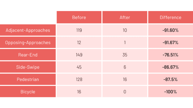
Following video analysis over a period of seven years, the city deployed LiDAR sensors to measure its effect on road safety. An initial sample of incidents (without LiDAR) was obtained from 25-29 July, 2022, before deploying Outsight’s solution and collecting data from October 10-14, 2022.
Through the experiment, the potential of LiDAR in enhancing road safety was shown by the following:
Incidents involving cyclists dropped to zero, from 16 observed incidents in the initial sample, while incidents involving pedestrians registered a sharp drop of 87.5%.
Meanwhile, incidents involving two vehicles registered a decrease ranging from 76.51% (rear-end collisions) to 91.67% (opposing approaches).
Ad Loading...
“Outsight has been a great partner for us in ingesting and processing huge quantities of LiDAR data," said Bellevue Mobility Planning and Solutions Manager Franz Loewenherz. "And rendering it in a manner that simplifies it to only those issues that are most relevant for us to intervene on from a safety standpoint.”
Kevin Schlangen shares how Dakota County’s fleet moved from reactive repairs and limited oversight to a more structured approach built around planning, training, and long-term cost control.
New York City is expanding the use of pedestrian alerts and intelligent speed assistance across its non-emergency fleet. The executive order establishes new technology requirements for future vehicle purchases while accelerating retrofits on thousands of existing municipal trucks.
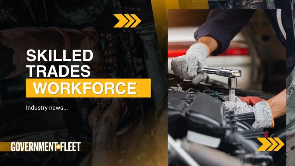
The alliance plans to develop a stronger pipeline between training programs and available jobs while examining workforce efforts already underway across the country.
Three public fleet leaders explain how they use real-world vehicle data and long-term planning to keep aging assets in service and make more informed replacement and budgeting decisions in a high-cost environment.