

Networkfleet Launches Satellite Maps for Wireless Fleet Management
- New mapping capability displays vehicles in real-world setting -
SAN DIEGO - March 11, 2009 - Networkfleet, Inc. today announced the availability of high-resolution satellite and hybrid maps in its flagship Networkfleet wireless fleet management system. The new mapping capability gives fleet managers the ability to observe vehicles in a real-world setting with 3-D earth imagery. This new functionality provides a more accurate and realistic depiction of a vehicle's location and its geographical surroundings.
Networkfleet combines GPS vehicle location tracking with precise diagnostic monitoring to give fleets a complete and accurate picture of their vehicle operations. With the new mapping capability, fleet managers log in to a secure Web site and observe vehicles on a street map, a satellite map, or a combination hybrid map. They can also use the new mapping capability to more easily set up landmarks and establish geofences.
"At Networkfleet, we are continually adding new functionality to our product based on feedback from our large user base," said Keith Schneider, president of Networkfleet. "Fleets of all sizes and types are looking to partner with Networkfleet because of our stability and long term market perspective. Satellite mapping is another of our ongoing enhancements designed to help fleet managers better understand how their vehicles are being used."
The enhanced mapping functionality is immediately available to Networkfleet subscribers and new users via its Web-based Networkfleet wireless fleet management system.
More Telematics

Connecticut Renews Fleet Telematics Agreement, Adds Automation Tools
Connecticut is expanding the use of automation within its fleet operations as part of a renewed telematics agreement. The new tools are designed to reduce manual reporting, streamline compliance tasks, and support management of the state's more than 3,600 vehicles.
Read More →
Tennessee DOT Selects Geotab as Fleet Telematics Provider
As state transportation agencies continue to expand their use of connected vehicle technologies, the Tennessee Department of Transportation is moving forward with a new telematics deployment. The initiative is expected to provide greater insight into fleet activity, asset utilization, and maintenance operations.
Read More →
City of Temple Enhances Fleet Operations with New Telematics Technology
The City of Temple is deploying a new Geotab telematics system across multiple municipal departments to improve fleet maintenance, safety monitoring and operational efficiency.
Read More →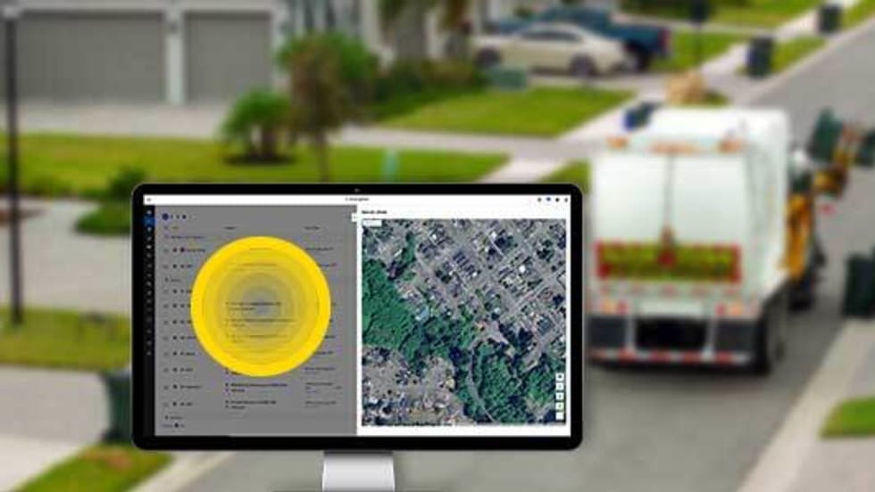
3 Ways Fleet Tech Builds Public Trust
Managing a state or local fleet comes with levels of accountability private companies don’t have. Read how modern fleet technology helps elevate visibility and safety to strengthen community trust.
Read More →
Geotab Launches Next-Gen GO Devices to Strengthen Oversight and Data Security
Next-generation telematics platform promises stronger diagnostics, asset tracking, and actionable insights.
Read More →Ford Pro Telematics Introduces In-App Asset Tracking
Ford Pro Telematics expands its abilities.
Read More →
Distracted Driving and Samsara AI Safety
The U.S. public sector continues to use AI technology to combat the dangers of distracted driving.
Read More →
Teletrac Navman’s TN360 Now Connects with Factory-Fitted Telematics for Easier Fleet Oversight
Agencies can now tap into factory-installed vehicle data within TN360 without taking vehicles out of service for hardware installs.
Read More →
Element, Samsara Partner to Launch Comprehensive Fleet and Operations Management Offering
This joint offering streamlines procurement and onboarding for shared customers to deliver greater safety and efficiency for fleets.
Read More →
7 Ways Fleet Intelligence Can Improve Safety, Savings, and Service
Fleet intelligence technology delivers actionable insights to optimize multiple aspects of government fleet safety and service.
Read More →