

In These Cities, Fleet Vehicles Are Roaming Data Centers
Telematics providers and fleets are collecting and reporting ‘beyond-the-vehicle’ data that informs decisions relating to operations, customer service, and public works.


Telematics providers are working with government fleets to collect and report ‘beyond-the-vehicle’ data that informs decisions relating to operations, customer service, and public works.
Image: Getty ImagesFleet vehicles equipped with air-quality monitoring “hats” roam the streets of Houston as part of a collaboration between the city’s health department and the nonprofit Environmental Defense Fund.
Houston is serious about air quality. Officials monitor a list of 20 parameters from eight (soon to be nine) continuous air monitoring sites several miles apart and operate “MAAML,” for “mobile ambient air monitoring laboratory,” a modified Ford E-Series camper filled with instruments and sensors that can be dispatched to hot spots.
Last year, the city accepted an invitation from the nonprofit Environmental Defense Fund (EDF), working in partnership with telematics provider Geotab, to attach air-quality monitors to two fleet vehicles. Affixed with magnets, the “hats” use antenna-style intakes and optical particle counters to measure levels of black carbon and PM2.5, a form of particulate matter, wherever and whenever the vehicles are in use.
“Other cities have monitored their air quality with specialized vehicles carrying specialized instruments. Houston is the first city that has monitored pollution using their own, regular vehicles doing their regular job,” said Aileen Nowlan, a senior manager focusing on smart cities innovation at EDF.
Those two cars, both driven by Houston Health Department (HHD) investigators, could only be expected to travel a fraction of Houston’s roads and highways. But they did find a few hot spots. And Nowlan said that, by equipping 30 vehicles with air-quality hats, 30% of the city could be covered in just six months, and smaller communities could do even more with far less. “People assume you’d have to put monitors on all the vehicles or thousands of vehicles. With telematics, you’re able to pick the best vehicles.”
The Houston/EDF project is just one example of a new trend in connected-vehicle technology: leveraging the miles traveled by city-owned vehicles to collect and report data the city can use to identify and redress problems not necessarily related to fleet — all while optimizing fleet operations.
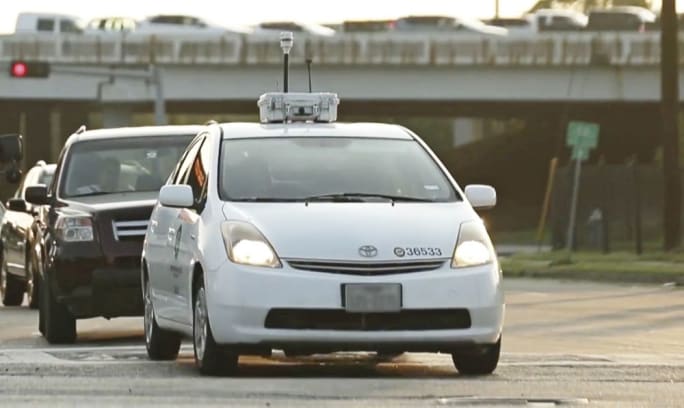
Fleet vehicles equipped with air-quality monitoring “hats” roam the streets of Houston as part of a collaboration between the city’s health department and the nonprofit Environmental Defense Fund.
Photo courtesy of City of Houston
Houston, We Have a Solution
Naomi Macias of the Houston Health Department said her office was proud to be part of the experiment. And it paid off with an entirely new level of insight into vehicle performance and driver safety.
“Within our first two, three months on the system, our lead vehicle liaison said, ‘You would not believe this reporting,’” said Macias, who serves as bureau chief for HHD’s consumer health division. “The biggest thing we gained was the safety aspect.”
In March, RoadBotics and Elgin Sweeper Co. partnered to launch an ambitious project in the State of Florida: Municipal-owned Elgin street sweepers were equipped with windshield-mounted smartphones loaded with RoadBotics’ RoadSense app. The app uses machine learning to identify potholes, cracks, and other hazards, building a map of road damage with no input from the driver.
Last fall, Montgomery, Ala., Director of Public Works Chris Conway and Director of Fleet Management Walt Lilley connected with Rubicon Global and its SmartCity waste and recycling solutions platform. They outfitted 80 sanitation department vehicles with a smartphone loaded with Rubicon’s hauler-specific app and a telematics “pod” capable of communicating with headquarters and each other.
Lilley said he was hopeful adding telematics would improve driver safety and vehicle health, opting for catastrophic-level vehicle health alerts. “I can’t even count the number of saves. I really don’t know. But our lot is a lot fuller every morning, because when we get notifications and contact sanitation leadership, they tell the drivers to bring them in,” he said.
The new technology also improved customer service, Conway added, but why stop there?
“From the very beginning, we said, ‘Look, we’ve got north of 1,000 miles of streets here, and we’re driving them two or three times a week. What else could we collect?’” Conway said. “So our drivers have the ability to input certain items like potholes, property maintenance issues, graffiti — anything we might be relying on an inspector to canvas.”
If a driver spots an overgrown front lawn, for example, he or she can pick up the phone, snap a photo, and select one of up to 10 customizable “exceptions” listed in a pop-up menu. The location is tagged automatically, and the alert is routed to the city’s 311 system.
“Rubicon coined the phrase ‘roaming data center,’ and we bought into that concept,” Conway said. “Obviously your primary mission is waste and sanitation. We’re not going to turn you into an inspector. We’re just saying that, if you see it, you can tag it.”
Sanitation workers in the City of Montgomery, Ala., can use a smartphone to photograph and tag road hazards, code violations, and missed pickups thanks to new connected-vehicle technology.
Photo courtesy of City of Montgomery
Stop Spinning Steel
Also onboard with the SmartCity pilot was the City of West Memphis, Ark., where Amanda Hicks serves as city engineer. She had been on the job for about a year when the partnership was proposed last fall, and she had crunched enough numbers to know her city’s sanitation department had room to improve.
West Memphis was far behind similar-size cities in waste tons per route, pickups per hour, and stops per route. So in addition to driver safety and vehicle health, Hicks said she told Rubicon she wanted to track performance-based metrics: how many times each “tipper” empties a can, pickups per hour, and time spent idling. The system also tracks landfill diversion rates by logging and tagging each weigh station visit.
And like Conway and Lilley in Montgomery, Hicks has discovered the system benefits customer service as well.
“If the resident’s can is filled with water, their dog is loose, or the gate to the dumpster is locked, they don’t even have to call dispatch. Take a picture with the phone. It’s tagged to that address. It takes a lot of the guesswork out.”
Sanitation workers have tough jobs and aren’t often recognized, Hicks said, but they do draw their share of complaints. Empowering them to resolve those complaints — and lodge their own — must inevitably improve their working lives.
“It gives them a little pride in their work. ‘I saw that pothole and I reported it.’ Sanitation can become a culture where, even though you want to take pride in your city, it’s hard to get motivated to go over and above. I think sometimes we have to change the culture and take back the pride,” Hicks said.
What Is Fleet?
Amy Ford is all for the advancement of telematics technology in pursuit of safer, smarter cities. In April, the former chief of advanced mobility for the Colorado Department of Transportation (CDOT) joined the Washington, D.C.-based advocacy group Intelligent Transportation Society of America, where she serves as director of the Mobility on Demand Alliance.
“What’s defined as a government fleet is changing,” Ford said. “You used to have a fleet and a transit system. Now Uber and Lyft are becoming an arm of that. Some agencies are trying to provide first-mile-to-last-mile connectivity. It’s an interesting transition.”
While with CDOT, Ford helped establish a partnership with Panasonic that included the development of a data ecosystem and installation of telematics equipment in 100 state-owned vehicles that routinely travel the I-70 corridor and 100 stationary, roadside vehicle-to-everything (V2X) units. The safety-focused system was designed to relay critical data such as traffic volume, collision sites, and hazardous road conditions — all transmitted at a rate of 2 billion datapoints per hour — and warn drivers before they encounter them.
“It’s telling you, ‘Crash ahead, detour now’ in a head-up display and audio built into the vehicle. It might seem similar to Waze. The difference is this is super-fast and super-accurate,” Ford said. “And if a vehicle’s airbag deploys, it brakes hard, or the tires are slipping, that data is sent 10 times per second, fed into the system, and aggregated. The vehicle is telling you what’s going on.”
More Telematics

Connecticut Renews Fleet Telematics Agreement, Adds Automation Tools
Connecticut is expanding the use of automation within its fleet operations as part of a renewed telematics agreement. The new tools are designed to reduce manual reporting, streamline compliance tasks, and support management of the state's more than 3,600 vehicles.
Read More →
Tennessee DOT Selects Geotab as Fleet Telematics Provider
As state transportation agencies continue to expand their use of connected vehicle technologies, the Tennessee Department of Transportation is moving forward with a new telematics deployment. The initiative is expected to provide greater insight into fleet activity, asset utilization, and maintenance operations.
Read More →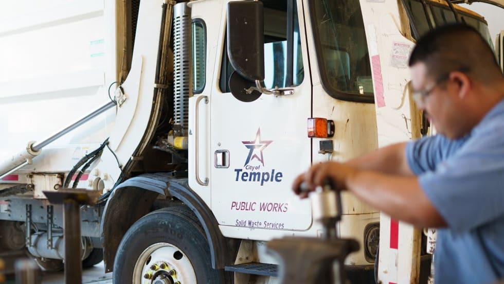
City of Temple Enhances Fleet Operations with New Telematics Technology
The City of Temple is deploying a new Geotab telematics system across multiple municipal departments to improve fleet maintenance, safety monitoring and operational efficiency.
Read More →
3 Ways Fleet Tech Builds Public Trust
Managing a state or local fleet comes with levels of accountability private companies don’t have. Read how modern fleet technology helps elevate visibility and safety to strengthen community trust.
Read More →
Geotab Launches Next-Gen GO Devices to Strengthen Oversight and Data Security
Next-generation telematics platform promises stronger diagnostics, asset tracking, and actionable insights.
Read More →Ford Pro Telematics Introduces In-App Asset Tracking
Ford Pro Telematics expands its abilities.
Read More →
Distracted Driving and Samsara AI Safety
The U.S. public sector continues to use AI technology to combat the dangers of distracted driving.
Read More →
Teletrac Navman’s TN360 Now Connects with Factory-Fitted Telematics for Easier Fleet Oversight
Agencies can now tap into factory-installed vehicle data within TN360 without taking vehicles out of service for hardware installs.
Read More →
Element, Samsara Partner to Launch Comprehensive Fleet and Operations Management Offering
This joint offering streamlines procurement and onboarding for shared customers to deliver greater safety and efficiency for fleets.
Read More →
7 Ways Fleet Intelligence Can Improve Safety, Savings, and Service
Fleet intelligence technology delivers actionable insights to optimize multiple aspects of government fleet safety and service.
Read More →